-
Welcome to AlpineZone, the largest online community of skiers and snowboarders in the Northeast!
You may have to REGISTER before you can post. Registering is FREE, gets rid of the majority of advertisements, and lets you participate in giveaways and other AlpineZone events!
You are using an out of date browser. It may not display this or other websites correctly.
You should upgrade or use an alternative browser.
You should upgrade or use an alternative browser.
First Snowfalls, Upcoming weather and Storms of winter 2023-2024. Storm snow totals, Observations and Predictions?
- Thread starter MidnightJester
- Start date

Just altered my dates from Tues Wed to Wed Thurs.Just made my reservation for Tues and Wed nights up the access road.
kingslug
Well-known member
Ill be happy to be home by wednesday
MidnightJester
Active member
- Joined
- Oct 7, 2011
- Messages
- 913
- Points
- 43
There is just incoming SNOW dropping everywhere!! Who will be the winner after 2-3 days of SNOW!!
Thank you Ullr and Mother Nature : )~
 madriverglenweather.blogspot.com
Late Wednesday is just the beginning. The elevation sensitive and colder part of our programming begins Thursday and it is an impressive setup. The coastal low near Cape Cod will continue to push northeast, but at a very, very low speed. This will allow the upper air support and decayed occluded Midwest low to catch up and allow for a more consolidated east coast storm by midday Thursday. Even as valley locations continue to see occasional bursts of wet snowfall with above-freezing temperatures, the mountains will be receiving heavier, even drier snowfall with colder temperatures. Valley areas are unlikely to see more than a foot of snow on the ground at any point during the storm even as snowfall amounts approach 2 feet at and above 3000 feet by late Thursday. Furthermore, the very slow-footed personality of this storm will allow snowfall to keep going and going. Thursday night, Friday, Friday night into early Saturday the snow will continue to fall, finally tapering off with some sun potentially returning for late Saturday which is just incredible. Snowfall, which again, is unlikely to ever produce a snow cover of more than a foot in valley areas, is likely to exceed 30 inches at 3,000 feet with much of it relatively dry and falling over a span of 3 days.
madriverglenweather.blogspot.com
Late Wednesday is just the beginning. The elevation sensitive and colder part of our programming begins Thursday and it is an impressive setup. The coastal low near Cape Cod will continue to push northeast, but at a very, very low speed. This will allow the upper air support and decayed occluded Midwest low to catch up and allow for a more consolidated east coast storm by midday Thursday. Even as valley locations continue to see occasional bursts of wet snowfall with above-freezing temperatures, the mountains will be receiving heavier, even drier snowfall with colder temperatures. Valley areas are unlikely to see more than a foot of snow on the ground at any point during the storm even as snowfall amounts approach 2 feet at and above 3000 feet by late Thursday. Furthermore, the very slow-footed personality of this storm will allow snowfall to keep going and going. Thursday night, Friday, Friday night into early Saturday the snow will continue to fall, finally tapering off with some sun potentially returning for late Saturday which is just incredible. Snowfall, which again, is unlikely to ever produce a snow cover of more than a foot in valley areas, is likely to exceed 30 inches at 3,000 feet with much of it relatively dry and falling over a span of 3 days.
Snow Outlook
MAD RIVER AREA
Valley areas a very wet 8-16 with never more than a foot on the ground
Mountains: Some wet snow early, more powder Thursday, Friday and into early Saturday with 27-54 inches.
Weather Channel

Accuweather

Fox Weather

Hmmmmmmmmmm???
"The storm this week will bring down trees and power lines over a widespread area," Lundberg explained.
The combination of wet, clinging snow in the northern part of the storm, with the emergence of some buds on the trees and high winds within and outside of the snow area, will likely trigger the damage. Some neighborhoods may be without power for days as streets and secondary roads may be clogged with heavy, wet snow as well as fallen trees and limbs.
Thank you Ullr and Mother Nature : )~
Over 30 inches of high elevation snow Wednesday through early Saturday and a high risk of sunshine on April 8
When it comes to April weather conditions in Vermont, I usually don't get a chance to say a lot of nice things. Snow-melt, mud, clouds, wind...
madriverglenweather.blogspot.com
Snow Outlook
MAD RIVER AREA
Valley areas a very wet 8-16 with never more than a foot on the ground
Mountains: Some wet snow early, more powder Thursday, Friday and into early Saturday with 27-54 inches.
Weather Channel
Accuweather
Fox Weather
Hmmmmmmmmmm???
Major impacts to include flooding, power outages and travel problems
This storm will have worse impacts than the storm from mid-March, AccuWeather Senior Meteorologist and New England native Joe Lundberg said."The storm this week will bring down trees and power lines over a widespread area," Lundberg explained.
The combination of wet, clinging snow in the northern part of the storm, with the emergence of some buds on the trees and high winds within and outside of the snow area, will likely trigger the damage. Some neighborhoods may be without power for days as streets and secondary roads may be clogged with heavy, wet snow as well as fallen trees and limbs.
Last edited:
kingslug
Well-known member
Pretty much when i get home..hmm
I leave 20 to 28 inches
I come back.......
I leave 20 to 28 inches
I come back.......
I'm rolling the dice with noco. I'm pretty sure wildcat will be fucked but maybe the tomcat could spin. If not attitash might be OK. If all else goes to shit I'll buy a walk up Bretton woods ticket which would kinda hurtAttitash, cannon or stowe? Wildcat will be too windy
Edd
Well-known member
BW is where I’ll be. Safer for winds and looks like they’ll get some.I'm rolling the dice with noco. I'm pretty sure wildcat will be fucked but maybe the tomcat could spin. If not attitash might be OK. If all else goes to shit I'll buy a walk up Bretton woods ticket which would kinda hurt
If I end up there ill roll in around 10 ill keep an eye out. Would be a lovely drive through the notch lolBW is where I’ll be. Safer for winds and looks like they’ll get some.
BodeMiller1
Well-known member
The storm is going to dump from Bristol, NH to Sugarloaf. It's jogging East.
MidnightJester
Active member
- Joined
- Oct 7, 2011
- Messages
- 913
- Points
- 43
I have been seeing the weather shifts and getting 18" will be a happy starting point for anywhere Vermont. Anything past that is just bonus SNOW : ) Will be interesting to see the final SNOW tallies on FRI/SAT and where the SNOW falls. The mountain elevation if it can wring more SNOW out of the moisture will make the numbers go up hopefully.The storm is going to dump from Bristol, NH to Sugarloaf. It's jogging East.
BodeMiller1
Well-known member
The storm is winding up and will give us a lot. The bad news is Monday the 8th looks sunny and with all the folks coming up here it's going to be a freak for all. [SIC].
Abandon all hope for those that enter.
MEOW
Abandon all hope for those that enter.
MEOW
Attachments


KustyTheKlown
Well-known member
honestly dont think i will feel any/much effect of eclipse crowding. traveling to well south of totality. driving from 4-8 am saturday and 3-7 pm sunday. no one will be trafficing in the middle of friday night/saturday morning. and any traffic on sunday will be going north.
MidnightJester
Active member
- Joined
- Oct 7, 2011
- Messages
- 913
- Points
- 43
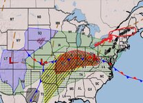
The Storm system is here. This is the newest(6am) SNOW forecast drop zone map I could find.
Things have shifted North and East slightly. Overall still looking at a minimum of 12"-18" at almost every Mountain.
WEATHER CHANNEL

Things have shifted North and East slightly. Overall still looking at a minimum of 12"-18" at almost every Mountain.
WEATHER CHANNEL
KustyTheKlown
Well-known member
snow has begun in SoVT
kingslug
Well-known member
Roads..will be sporty..
Edd
Well-known member
Having lunch now in North Conway. I’m normally one to go out for dinner on overnights here but the forecast has me planning for hunkering down tonight. Tomorrow’s going to be interesting, I plan to be up early shoveling snow before going skiing.
urungus
Well-known member
